Blue Carbon Canada Research Projects
Blue Carbon
What is it and why we are studying it
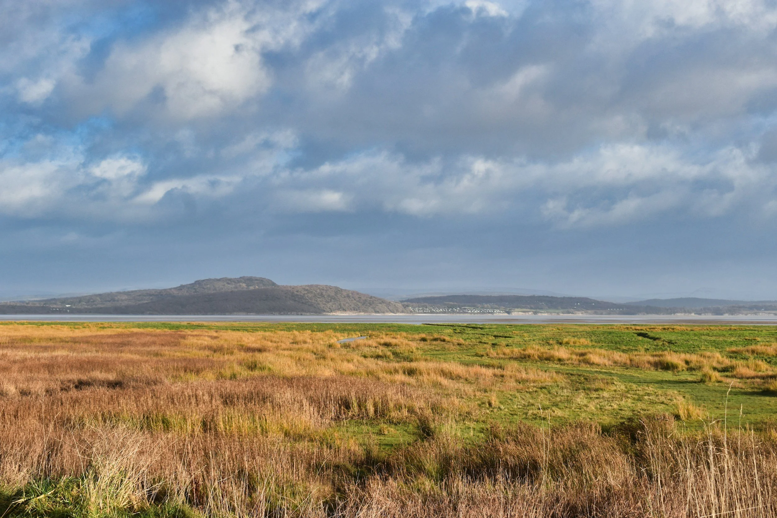
‘Blue Carbon’ is the carbon captured and stored in the ocean, including by salt marsh, seagrass, and mangrove ecosystems. It is estimated that these ‘blue carbon ecosystems’ (BCEs) can sequester 2-10X more carbon than terrestrial forests, making these habitats ideal for nature-based climate change solutions. Despite this, these ecosystems are also vulnerable to habitat destruction and degradation, as well as to climate change. This not only impacts the potential climate change solution capacity, but actually turns them into a significant source of carbon dioxide and contributor to climate change. Protection and restoration of blue carbon ecosystems is thus essential.
Blue Carbon Canada is a collaborative research effort to produce a nationwide assessment of the potential for Canada’s oceans to serve as blue carbon. In phase 1, we will estimate the extent of potential blue carbon habitats - marsh, seagrass, kelp, soft sediments - in all three of Canada’s oceans, calculate their current carbon drawdown potential, and project this out to 2030 and 2050 under different climate change scenarios.
Diagram from Eneos Mirai Hub
Phase 2 will build on its previous and ongoing research by continuing to resolve ecosystem distribution, carbon storage, and sequestration rates in BCEs. This work will also assess the co-benefits, such as biodiversity, ecosystem services, and economic value. All of this data will be incorporated into decision-science tools to produce the first national prioritization of nature-based solutions for Canada’s BCEs.
Ongoing and New Research
(Phase 1 & 2)
Model the current mitigation capacity of Canada’s blue carbon ecosystem

Model and map the current extent of blue carbon ecosystems
-
Blue carbon ecosystems (BCEs) are important reservoirs for carbon that are expected to provide significant climate mitigation benefits. Canada’s extensive coastline supports three key BCEs, including salt marshes, seagrass beds, and kelp forests, but their current extent is unknown. We will reconstruct the contemporary distribution of salt marshes, eelgrasses, and kelp forests across Canada’s Pacific, Atlantic, and Arctic coasts, using historical observations, species distribution modeling approaches, and our new high-resolution coastal ocean data products.
Phase 2 will continue to resolve uncertainty in the distribution and refine the models. In particular, we are harnessing remote sensing and a novel algorithm to map salt marsh extent and changes across Canada.
Synthesize the drawdown capacity and estimate Canada’s current blue carbon
-
Despite growing interest in leveraging blue carbon ecosystems (BCEs) for ocean climate solutions, the carbon drawdown capacity of these systems is understudied in Canada. We will combine new current extent maps for salt marshes, seagrass beds, and kelp forests with the best available datasets on carbon sequestration and storage rates to produce the first nationwide assessment of the current climate change mitigation capacity of BCEs across the three Canadian coastlines (Pacific, Atlantic, and Arctic).
McHenry, J., D.K. Okamoto, K. Filbee-Dexter, K. Krumhansl, K.A. MacGregor, M. Hessing-Lewis, B. Timmer, P. Archambault, C.M. Attridge, D. Cottier, M. Costa, M. Csordas, L.E. Johnson, J. Lessard, A. Mora-Soto, A. Metaxas, C.J. Neufeld, O. Pontier, L. Reshitnyk, S. Starko, J. Yakimishyn, J.K. Baum. 2025. A blueprint for national assessments of the blue carbon capacity of kelp forests applied to Canada’s coastline. npj Ocean Sustainability. 4:30. DOI | PDF | Supp Info | Supp Data
Improving GHG emissions accounting for salt marshes through new field data & modelling
-
Like other BCEs, most salt marshes are characterized by low to negligible rates of CH4 and N2O emissions. Some marshes, however, emit CH4 and N2O, but the factors controlling these emissions–particularly the role of salinity–remain unclear. This not only creates uncertainty about the drawdown capacity of Canada’s salt marshes but also about the effects of potential nature-based solutions, such as marsh restoration, remediation, and protection, on GHG budgets. Using existing chamber measurement records, supplemented with targeted new chamber CH4 and N2O measurements, and a new coastal eddy covariance tower network in B.C. and Atlantic Canada, we will compare GHG fluxes and drivers of C uptake across marshes on Canada’s east and west coasts. This research will refine salt marsh GHG budget estimates and advance understanding of the drivers of salt marsh C uptake and GHG dynamics, knowledge that is required to accurately quantify salt marsh ecosystem services and to identify salt marsh areas best suited to nature-based solutions, and hence to informing spatial prioritizations.
Assess co-benefits & value of Canada’s blue carbon ecosystems at the national- and regional-scale

Assess the biodiversity co-benefits of Canada’s BCEs
-
While the biodiversity value of BCEs is generally recognized, a lack of data for biodiversity in Canadian BCEs has hindered specific assessments to date. The extraordinary size of Canada’s coastline and dearth of systematic or large-scale biodiversity monitoring programs render quantitative analyses of biodiversity sensu stricto impossible. Instead, 1) for a national assessment, we will collate records of species occurrences and distributions for each BCE from government and other open-source databases, primary and grey literature overlay these on new Canadian BCE distribution maps (from BCC1). 2) Within each priority region, we will augment these with species records collated from regional BCE biodiversity datasets to produce finer-resolution, quantitative BCE biodiversity assessments, with a focus on estimating the marginal value of BCE habitat for diversity relative to other habitats. We will summarize biodiversity patterns, and species’ meta-data, including threatened status, flagship species, endemics, culturally valued, economically valued, and use these data to produce quantitative spatially explicit ‘biodiversity value indices’ that can be adjusted according to the values of partners and other regional experts, to inform spatial prioritizations for NBS in BCEs.
Quantify ecosystem services and economic value of Canada’s BCEs
-
Salt marshes, eelgrass meadows, and kelp forests also provide an array of valuable ecosystem services, from coastal protection to nutrient cycling, fisheries enhancement and food security, tourism, recreation, and habitat for biodiversity and Species-at-Risk. However, the magnitude and economic values of these services, and hence Canada’s BCEs overall, remain poorly resolved. To meet this need, we will quantify the key measurable services for each ecosystem and assign economic values for those with market values or relevant proxies. Together, this information, when coupled with our Canadian BCE distributions, will enable service quantification and valuation for each service individually and all combined, with estimations and associated uncertainties of these for all BCEs combined, by ecosystem. These estimates will be produced nationally and for priority regions.
Quantify Canada’s protected blue carbon assets and threats, and prioritize areas for new BCE nature-based solutions
Map the extent and value of Canada’s spatially protected BCEs
-
We will overlay estimates of the current extent of each of Canada’s blue carbon ecosystems with Canada’s protected and conserved areas, to quantify the proportion of each BCE that is currently protected by any form of a designated marine or terrestrial protected area (PA) and the proportion that would be covered by PAs proposed out to 2030. By doing this we will identify critical gaps in BCE protection.
Assess current and future threats that constrain Canada’s BCE nature-based solutions potential
-
An important knowledge gap for prioritizing nature-based solutions based upon Canada’s BCEs is assessing how coastal land use (e.g., cities, agriculture, logging, and infrastructure such as ports and pipelines) limits opportunities for the conservation and restoration of these ecosystems. We will fill this gap by mapping the distributions and intensities of existing coastal land uses that impact BCEs, by building on recent coastal cumulative impact assessments, updating data, and selecting impacts relevant to BCEs. We will overlay these maps with our BCE distributions to produce spatially-explicit estimates of Canada’s current ‘BCE nature-based solutions potential’–areas where new BCE spatial protections or restoration could, in theory, be implemented. Next, we will synthesize projections of coastal impacts (e.g. shipping terminal, pipeline), to generate best- and worst-case scenarios for coastal development, by decade, out to 2050. Combining these scenarios with projected changes in BCE distributions due to climate change, we will project where Canada’s blue carbon assets may be lost by the 2050 climate change mitigation target, without specific management interventions.
-
Identifying areas of highest priority to implement nature-based solutions for Canada’s blue carbon ecosystems requires the application of decision science, and specifically spatial prioritization. Here, by integrating our data products and employing the state-of-the-art spatial prioritization tool PrioritzR, we will identify suites of sites for new spatial protections and restoration efforts that optimize NBS benefits, while minimizing the costs to society. We will examine distinct scenarios, including which suite of new BCE protected area sites would maximize: 1) the economic value of BCE assets? 2) carbon storage in protected BCEs? or 3) all ecosystem services, including carbon storage and biodiversity, in protected BCEs (with assessment of ensuing trade-offs for this multi-objective prioritization)? Overall, these analyses will identify a suite of complementary sites that optimize blue carbon ecosystem-based NBS for all of Canada and at higher resolutions in our priority regions, for the least cost to society.
Prioritize new spatial protections and restoration to maximize BCE nature-based solutions in Canada
Project Canada's future blue carbon mitigation capacity
Project future blue carbon ecosystem distributions on each coast out to 2050
-
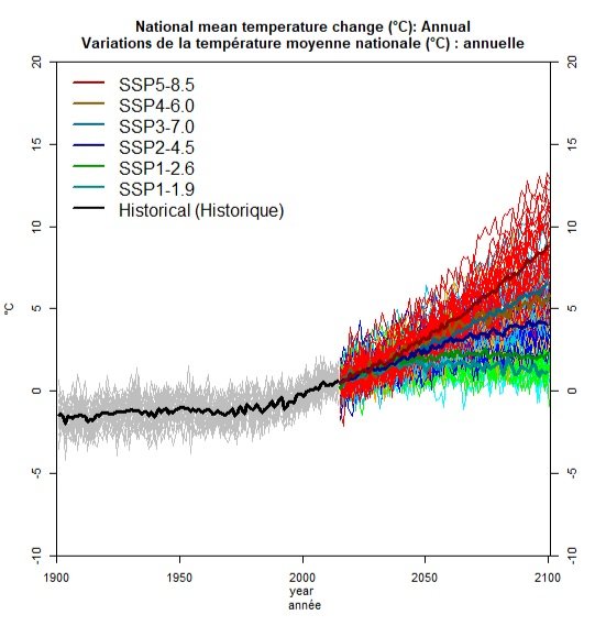
Climate change is rapidly reshaping blue carbon ecosystems (BCEs), shifting species distributions, driving species losses, and potentially altering the carbon drawdown dynamics of these important systems. Integrating our BCE distribution models with new state-of-the-art high resolution ocean climate projections, we will simulate changes in the distribution of salt marsh, seagrass, and kelp species under multiple climate change scenarios that are tailor made for Canada’s Pacific, Atlantic, and Arctic coastlines.

Project impacts of kelp halocarbon emissions on future climate
-
We will produce halocarbon emissions datasets by combining emission rates with projected kelp distributions, and use these to force the fully-coupled Earth system model forward to 2050. We will run ‘experiments’ of these model projections that account for uncertainty in halocarbon and GHG emissions, to yield a range of estimates for how much kelp halocarbon emissions contribute to global warming, from both direct radiative impacts and top-of-atmosphere radiative forcing, and to stratospheric ozone depletion.

-
Climate change threatens the persistence of blue carbon ecosystems, hence their future capacity to serve as ocean climate solutions. Combining future projections of BCE extents with synthesized estimates of carbon drawdown, we will produce the first nationwide assessment of the future mitigation potential of Canada’s BCEs.
Estimate Canada’s future blue carbon potential
Completed Projects
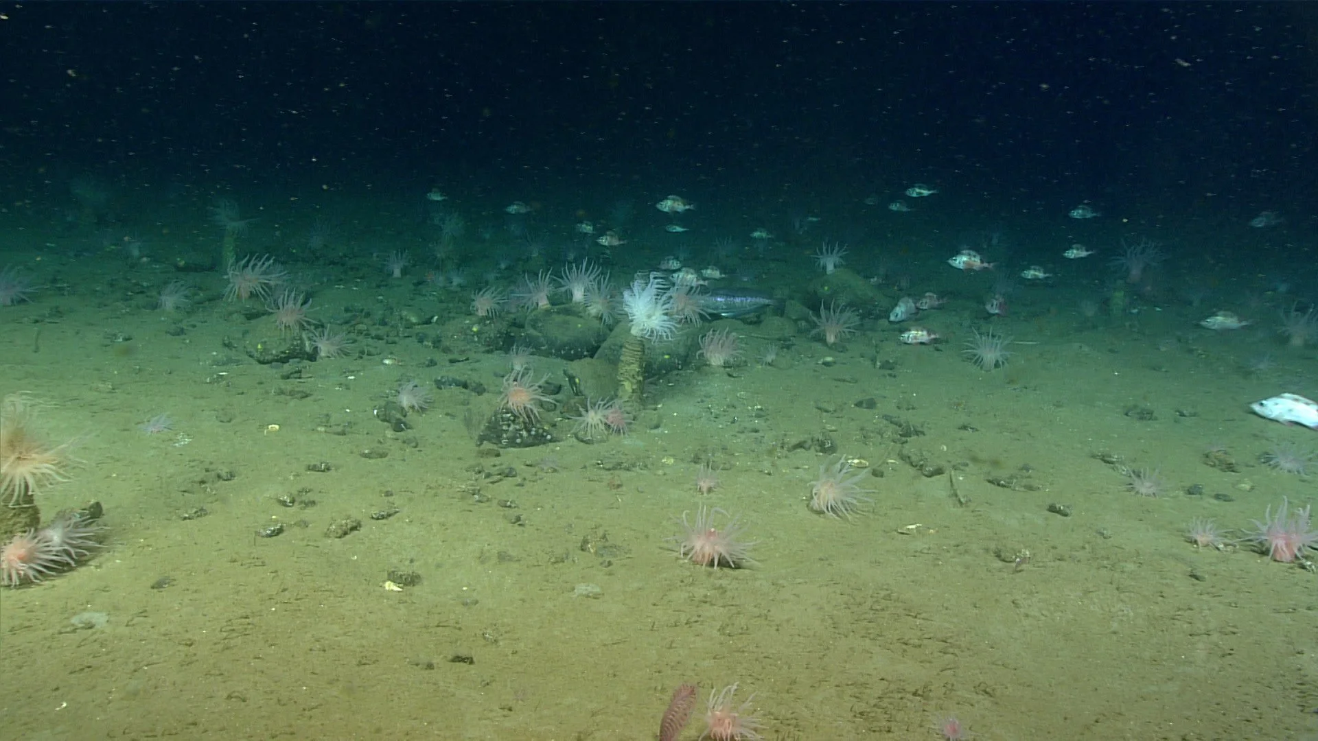
Assess the mitigation capacity of Canada’s marine soft sediment habitats under different protection scenarios
-
Seabed sediments contain one of the world’s largest stocks of organic carbon, acting as an important resource for limiting and mitigating climate change. In Canada, information on the size and distribution of these carbon stores is currently lacking. We will combine the best available datasets on seabed geology, morphology, hydrology and carbon content to model the surficial seabed sediment carbon stocks across Canada’s waters.
Epstein, G., S.D. Fuller, D. Hingmire, P. Myers, A. Peña, C. Pennelly, J.K. Baum. 2024. Predictive mapping of organic carbon stocks and accumulation rates in surficial sediments of the Canadian continental margin. Earth System Science Data. 16(5):2165-2195. DOI | PDF | Supp Mat | Data
Map Canada’s marine soft sediment habitats and estimate their carbon stores

Quantify the carbon stores that could be preserved through new marine spatial protections
-
There is mounting evidence that human activities, particularly mobile bottom fishing, are causing disturbance to seabed carbon stores, potentially causing the release of stored carbon as CO2 and limiting future burial capacity. We will assess current seabed protection strategies and consider whether new areas should be considered for protection due to their carbon storage capacity. We will also map the mobile bottom fishing footprint and evaluate how potential management of this activity could better protect carbon stores both now, and into the future.
Epstein, G., S.D. Fuller, L. Gullage, J.K. Baum. 2025. Mobile bottom fishing in the Canadian Pacific and Atlantic causes disturbance and risk to remineralisation of seabed sediment carbon stocks. Canadian Journal of Fisheries and Aquatic Science. 82: 1-22. DOI | PDF | Supp Mat | Data
Epstein, G., M. Turner, S.D. Fuller, S. Johannessen, E.M. Rubidge, and J.K. Baum. 2025. Protection of seabed sediments in Canada’s marine conservation network for potential climate change mitigation co-benefit. FACETS 10: 1-14. DOI | PDF | Supp Mat | Data
Model Canada’s blue carbon ecosystems

Develop high-resolution coastal ocean data products
-
Before high quality blue carbon ecosystem (BCE) distribution models can be made, we will develop fine-scale nearshore ocean products that will allow for more accurate models. This will be done using state-of-the-art modeling systems for a variety of data products along each of Canada’s coastlines.
Arta, Ryan; MacCready, Parker; Hingmire, Dipti; Baum, Julia K., 2025, "2km Resolution 3D Biogeochemical & Physical Oceanographic Model Predictions For British Columbia 1993-2022", https://doi.org/10.5683/SP3/YUUPKA, Borealis, V1
Develop high-resolution coastal ocean projections under different climate change scenarios
-
For accurate future projection BCE models, we will first project our ocean product models using different climate change scenarios out to 2050. This will allow for the calculation of marine heatwaves and other extreme climatic events that threaten BCEs.
Hingmire, D., J. McHenry*,J. Velletta*, V. Valenti, J.K. Baum. 2025. Added value of a priori bias correcting dynamically downscaled data for application to species distribution models - a case study for coastal British Columbia. In revision. *Authors contributed equally. Preprint: URL | PDF
Photo credits:
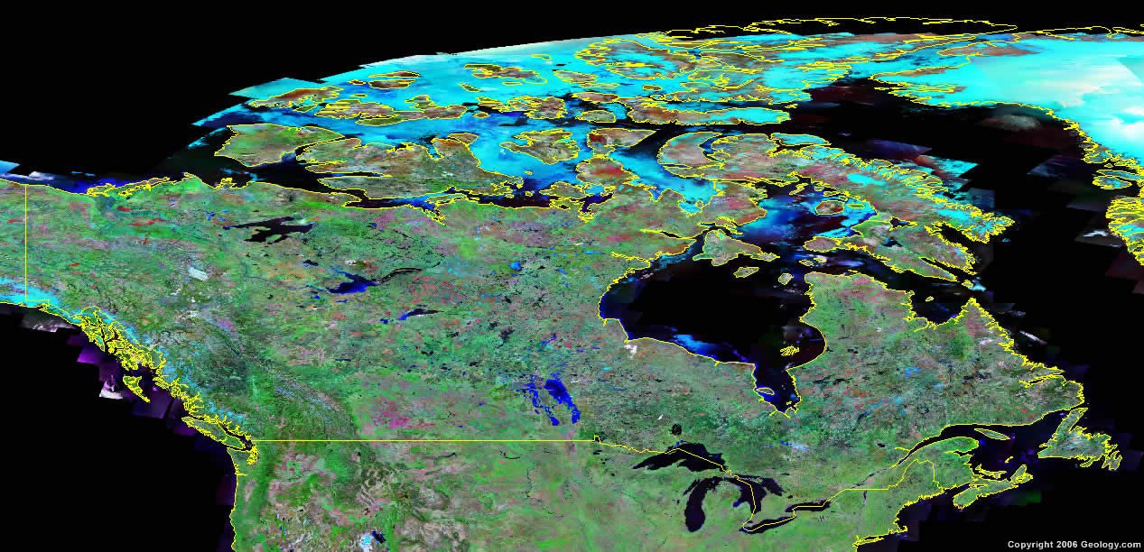
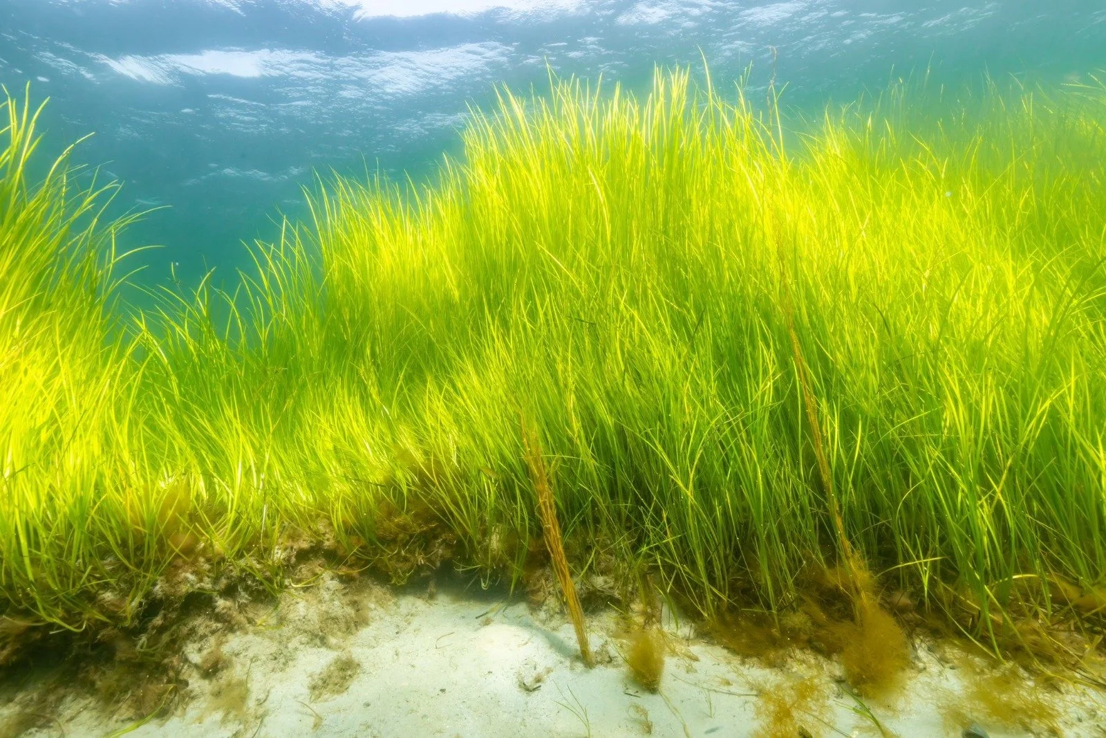
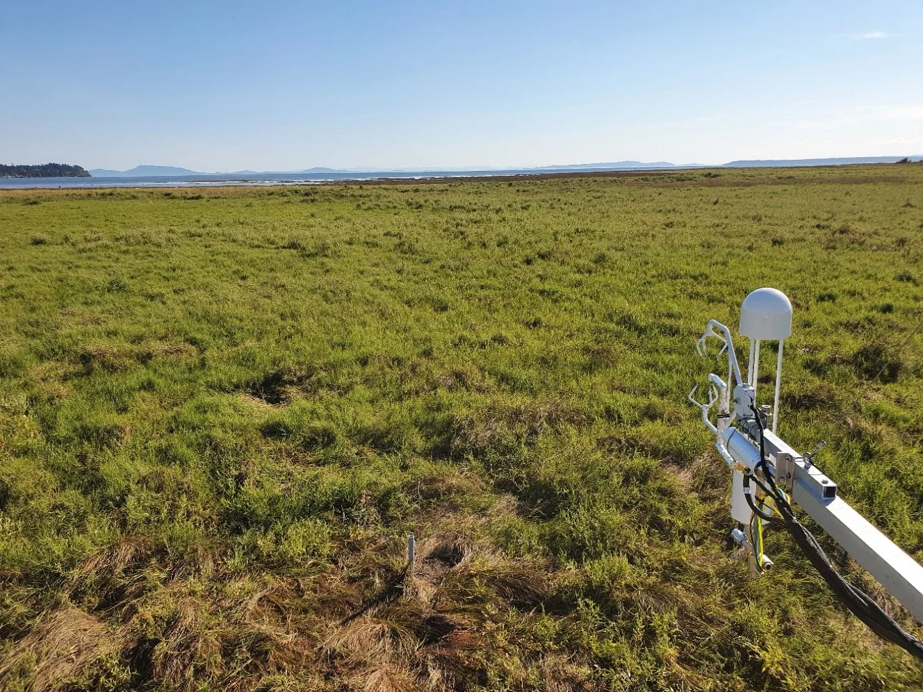
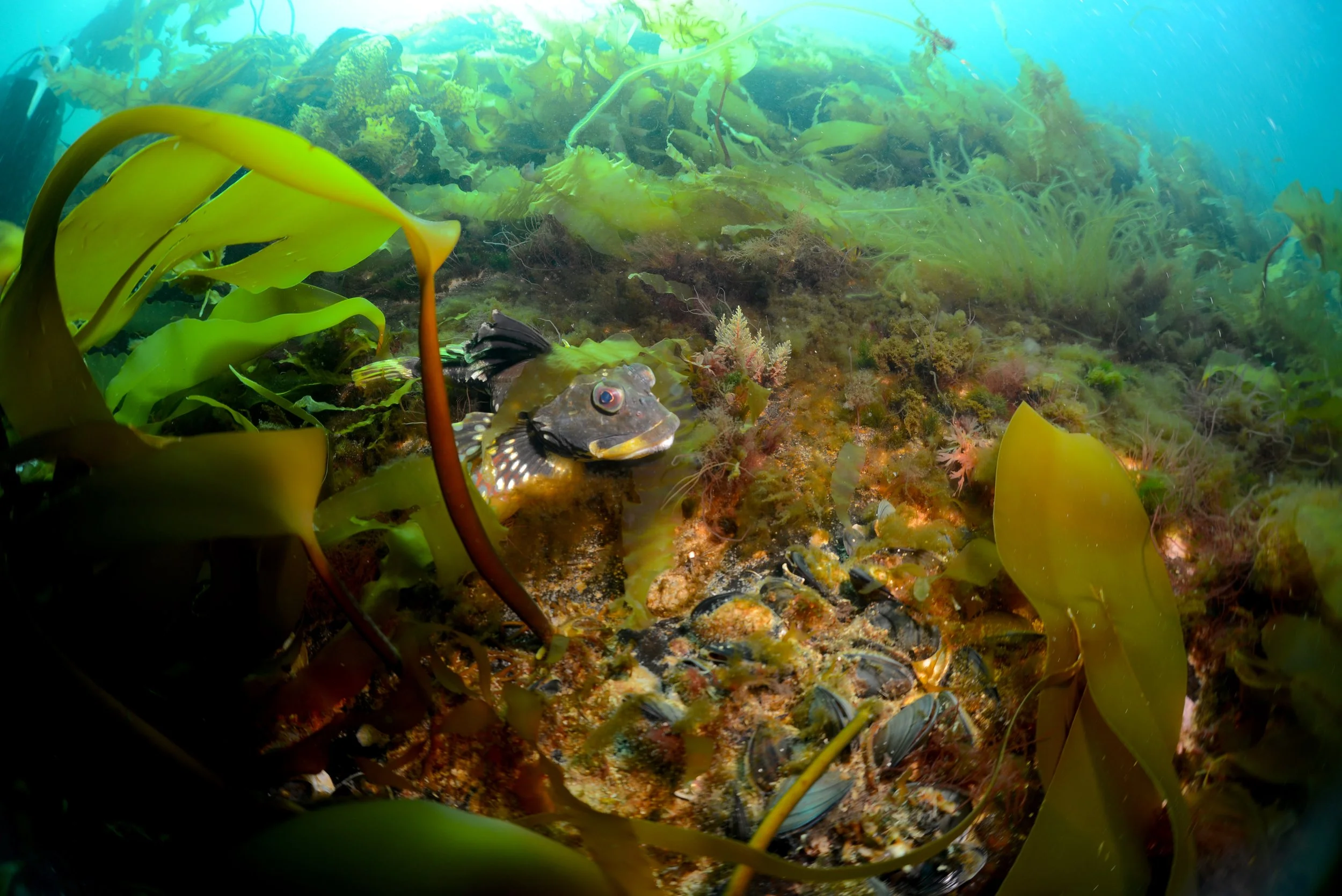
Canada via Satellite (Geology.com), Asseek River (Photographer Markus Thompson - property of Nature Trust of BC), Eelgrass (Kristina Boerder), Boundary Bay tidal marsh (Sara Knox), Moyeha River (Photographer Markus Thompson - property of Nature Trust of BC), Fish in kelp (Ignacio Garrido, Arctic Kelp), Coastal marsh (@andrew_hall), Coastal walkway (@kylethacker), Island (Kristina Boerder), Fulmore Shoal (Photographer Markus Thompson - property of Nature Trust of BC), Kelp Forest x2 (Fernando Lessa), Soft sediment (Image courtesy of the NOAA Office of Ocean Exploration and Research, Deep Connections 2019), trawling (Kelly Walker, NOAA), Ocean temperature (LiveOcean), temperature graph (Government of Canada)